


For being a long time member of a tactics based hunting forum, I am pretty terrible at communicating my tactics (because a lot of them I learned here and are well known to the members). However, LiDAR maps are an incredible resource for cyber scouting/e-scouting, and they are one tool that a lot of guys don't seem to know about.
I wrote a blog article about LiDAR maps and how I used them as part of my e-scouting on my recent trip to Iowa. If you're asking yourself "what the heck is LiDAR?", you might want to check the article out!
Article Link:
https://going4brokeoutdoors.com/next-level-e-scouting-for-whitetail-deer-with-lidar/
Here's an exaple of two benches crossing draws that aren't visible on traditional aerial maps or topo maps, but they really pop out on the LiDAR imagery.
A lot of Guys Don't Know About LiDAR Maps
-
seazofcheeze

- 500 Club
- Posts: 3864
- Joined: Wed Sep 18, 2013 1:13 pm
- Location: Billings, MT
- Status: Offline
A lot of Guys Don't Know About LiDAR Maps
You do not have the required permissions to view the files attached to this post.
-
DEERSLAYER

- Super Moderator
- Posts: 8353
- Joined: Sun Mar 14, 2010 3:22 pm
- Location: Western L.P. of MI
- Contact:
- Status: Offline
Re: A lot of Guys Don't Know About LiDAR Maps
Finding funnels like those would be awesome.
You cannot invade mainland America. There would be a rifle behind every blade of grass.
Isoroku Yamamoto, Japanese Admiral
Isoroku Yamamoto, Japanese Admiral
-
Dewey

- Moderator
- Posts: 36754
- Joined: Thu Mar 11, 2010 7:57 pm
- Location: Wisconsin
- Status: Offline
Re: A lot of Guys Don't Know About LiDAR Maps
I use LiDAR maps a lot when scouting/hunting Iowa hills. Really love the detail and how they give you an excellent feel for the elevation changes way better than topos can. Great for cyber scouting and seeing the terrain exactly how it is. Made things a whole lot easier. I sometimes have a hard time visualizing topos and verifying with LiDAR really confirmed what I was or wasn’t seeing.
-
Tsom

- 500 Club
- Posts: 832
- Joined: Fri Jan 13, 2017 5:25 am
- Location: W. Central MN
- Status: Offline
Re: A lot of Guys Don't Know About LiDAR Maps
I've been using them since learning about them somewhere on here. Really handy to have in new England but not all areas have it at least on the cal topo app. You can plainly see even stone walls that run all through the woods around here which can be used for easy navigation.
-
NorthStar

- 500 Club
- Posts: 1524
- Joined: Thu Sep 15, 2016 6:43 am
- Status: Offline
Re: A lot of Guys Don't Know About LiDAR Maps
Great, now I have something else to obsess over while I am supposed to be working…ha
“The lazy do not roast any game, but the diligent feed on the riches of the hunt.”
Proverbs 12:27 NIV
Proverbs 12:27 NIV
-
UncleBuck3268
- 500 Club
- Posts: 677
- Joined: Thu Feb 21, 2019 12:52 pm
- Facebook: NONE
- Location: Sheboygan County
- Contact:
- Status: Offline
Re: A lot of Guys Don't Know About LiDAR Maps
I’m not much for technology, so I’ll ask this. What platform are you guys using? Is it free?
-
Tsom
- 500 Club
- Posts: 832
- Joined: Fri Jan 13, 2017 5:25 am
- Location: W. Central MN
- Status: Offline
Re: A lot of Guys Don't Know About LiDAR Maps
I have it on the caltopo app on my phone. Not sure why I got a double post there but yes it is free. Here's another thread where its explained how to find that map layer in caltopo. viewtopic.php?f=3&t=54898&p=892029&hilit=Caltopo#p892029
-
Kokes
- 500 Club
- Posts: 1612
- Joined: Wed Sep 02, 2015 3:33 am
- Location: Parry Sound, Ontario
- Status: Offline
Re: A lot of Guys Don't Know About LiDAR Maps
great article but you forgot to post co-ords, just PM me instead maybe? 
all kidding aside this is a great article that many many deer hunters looking to up their game can benefit from, hope its gets the recognition it deserves! keep up the great content Seaz!!
all kidding aside this is a great article that many many deer hunters looking to up their game can benefit from, hope its gets the recognition it deserves! keep up the great content Seaz!!
-
ThePreBanMan

- 500 Club
- Posts: 2632
- Joined: Thu Jul 31, 2014 2:36 pm
- Location: Fairhaven, MA
- Status: Offline
Re: A lot of Guys Don't Know About LiDAR Maps
This is awesome!!!! Seriously, thanks man. I didn't know about this.
-
greenhorndave

- 500 Club
- Posts: 13851
- Joined: Tue Oct 09, 2018 11:23 am
- Location: SE WI
- Status: Offline
Re: A lot of Guys Don't Know About LiDAR Maps
Good topic. Thanks Jeremy!
Gotta use all the available tools to our advantage. And just because something looks perfect on lidar doesn't mean it's perfect in reality. But it's a great start.
I've heard of them and seen them, just haven't tried to find/use them yet.
That's gonna change.
Gotta use all the available tools to our advantage. And just because something looks perfect on lidar doesn't mean it's perfect in reality. But it's a great start.
I've heard of them and seen them, just haven't tried to find/use them yet.
That's gonna change.
----------
Sometimes when things get tough, weird or both, you just need to remember this...
https://youtu.be/d4tSE2w53ts
Sometimes when things get tough, weird or both, you just need to remember this...
https://youtu.be/d4tSE2w53ts
-
ThePreBanMan
- 500 Club
- Posts: 2632
- Joined: Thu Jul 31, 2014 2:36 pm
- Location: Fairhaven, MA
- Status: Offline
Re: A lot of Guys Don't Know About LiDAR Maps
I'm finding that it's showing some details, not on the topo maps in my area. It's helpful.
-
KLEMZ
- Posts: 1715
- Joined: Wed Jan 26, 2011 2:28 am
- Location: SE Wisconsin
- Status: Offline
Re: A lot of Guys Don't Know About LiDAR Maps
Great article and example Seaz! Congrats on the awesome buck!!
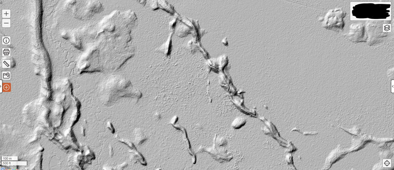
I've been geeking out over LiDAR maps for a few years now. As you stated, LiDAR reveals subtle features that mature bucks relate to. It doesn't matter if it's hill country, rolling terrain, or flat as a pancake...LiDAR will reveal important terrain.
Example...LiDAR eliminates a lot of the mystery in reading homogeneous swamps. All the little humps and points are easy to see. Almost as easy as a cattail swamp!
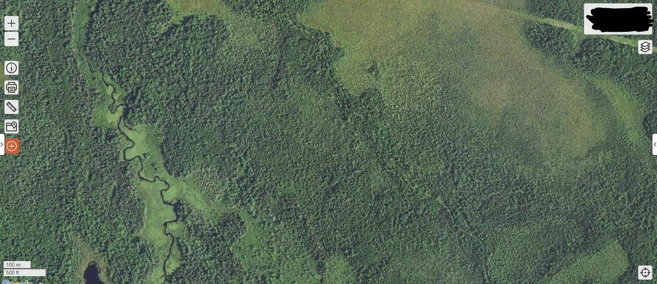
Typical aerial of homogeneous swamp
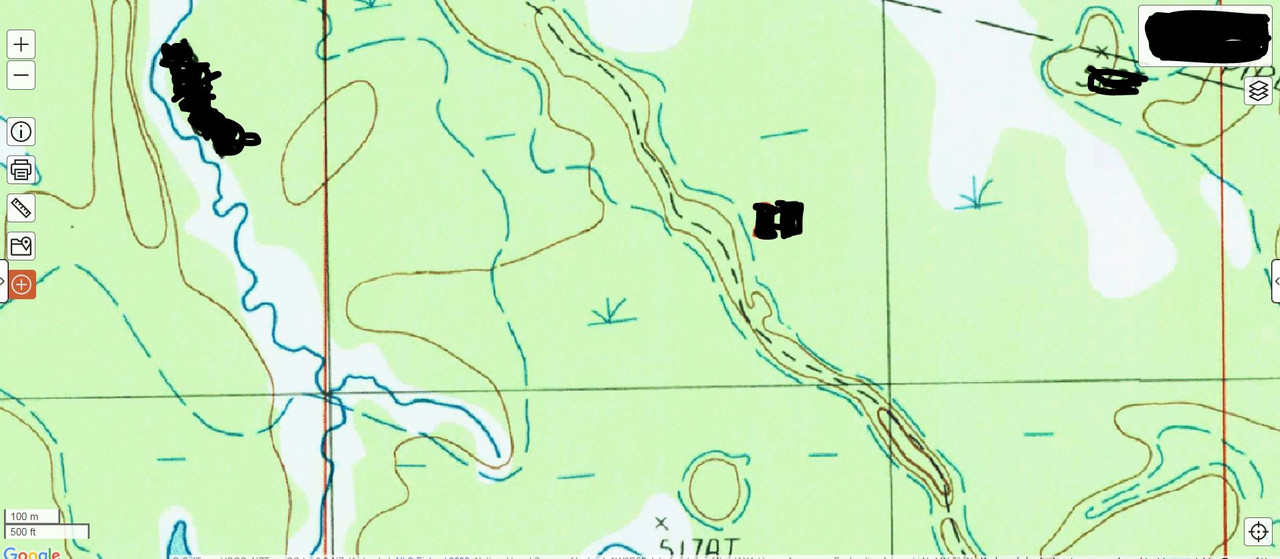
Standard topo view of same area
LiDAR view of same area
I will say that is is extremely helpful to have the LiDAR images on your GPS or phone so you can relate your location to it in real time while your scouting. Having that level of elevation detail also helps predict the dropping thermals at a stand site.
As already mentioned, Caltopo (free version) allows you to see this real time LiDAR data as long as you have cell coverage AND also have LiDAR coverage in your area on Caltopo. As I understand, they hope to have complete USA coverage by 2023....we'll see. Here is a link to show their current coverage
https://caltopo.com/map.html#ll=38.7669 ... D%7D%5D%7D
With Caltopo Pro ($50 annual I think), you can generate the LiDAR images into KMZ files and open them in Google Earth. This also allows you to have them on a Garmin GPS as a cutom map.
I've been geeking out over LiDAR maps for a few years now. As you stated, LiDAR reveals subtle features that mature bucks relate to. It doesn't matter if it's hill country, rolling terrain, or flat as a pancake...LiDAR will reveal important terrain.
Example...LiDAR eliminates a lot of the mystery in reading homogeneous swamps. All the little humps and points are easy to see. Almost as easy as a cattail swamp!
Typical aerial of homogeneous swamp
Standard topo view of same area
LiDAR view of same area
I will say that is is extremely helpful to have the LiDAR images on your GPS or phone so you can relate your location to it in real time while your scouting. Having that level of elevation detail also helps predict the dropping thermals at a stand site.
As already mentioned, Caltopo (free version) allows you to see this real time LiDAR data as long as you have cell coverage AND also have LiDAR coverage in your area on Caltopo. As I understand, they hope to have complete USA coverage by 2023....we'll see. Here is a link to show their current coverage
https://caltopo.com/map.html#ll=38.7669 ... D%7D%5D%7D
With Caltopo Pro ($50 annual I think), you can generate the LiDAR images into KMZ files and open them in Google Earth. This also allows you to have them on a Garmin GPS as a cutom map.
-
DEERSLAYER
- Super Moderator
- Posts: 8353
- Joined: Sun Mar 14, 2010 3:22 pm
- Location: Western L.P. of MI
- Contact:
- Status: Offline
Re: A lot of Guys Don't Know About LiDAR Maps
I sure wish I could find LiDAR in Caltopo. I don't know if Chrome isn't showing me everything or what the deal is but I don't see it & explorer doesn't show anything.
It's kind of frustrating. I could really use that option.
It's kind of frustrating. I could really use that option.
You cannot invade mainland America. There would be a rifle behind every blade of grass.
Isoroku Yamamoto, Japanese Admiral
Isoroku Yamamoto, Japanese Admiral
-
Tsom
- 500 Club
- Posts: 832
- Joined: Fri Jan 13, 2017 5:25 am
- Location: W. Central MN
- Status: Offline
Re: A lot of Guys Don't Know About LiDAR Maps
DEERSLAYER wrote:I sure wish I could find LiDAR in Caltopo. I don't know if Chrome isn't showing me everything or what the deal is but I don't see it & explorer doesn't show anything.
It's kind of frustrating. I could really use that option.
It's not actually listed as "lidar" in the layers, but if you hit the map layer button on the upper right corner of the map, at the top of the list is "base layers" in the top box select "shaded relief" and the next box down select "normal"
You do not have the required permissions to view the files attached to this post.
-
DEERSLAYER
- Super Moderator
- Posts: 8353
- Joined: Sun Mar 14, 2010 3:22 pm
- Location: Western L.P. of MI
- Contact:
- Status: Offline
Re: A lot of Guys Don't Know About LiDAR Maps
Tsom wrote:DEERSLAYER wrote:I sure wish I could find LiDAR in Caltopo. I don't know if Chrome isn't showing me everything or what the deal is but I don't see it & explorer doesn't show anything.
It's kind of frustrating. I could really use that option.
It's not actually listed as "lidar" in the layers, but if you hit the map layer button on the upper right corner of the map, at the top of the list is "base layers" in the top box select "shaded relief" and the next box down select "normal"Screenshot_20211204-203728.png
Thanks Tsom! I have been using the shaded relief feature. I was looking for the color enhanced images like seazofcheeze's image showed. I thought I might be able to see different colors for slight elevation changes for beds. I guess I'm getting ahead of technology a little. lol
It is helpful for sure in many area's. Thanks again for setting me straight.
You cannot invade mainland America. There would be a rifle behind every blade of grass.
Isoroku Yamamoto, Japanese Admiral
Isoroku Yamamoto, Japanese Admiral
-
- Advertisement
Who is online
Users browsing this forum: No registered users and 54 guests